Hardrian's Wall, Northumbia, United Kingdom, USA by Roger Clegg
Why are you reporting this puzzle?
Copyright-Roger Clegg
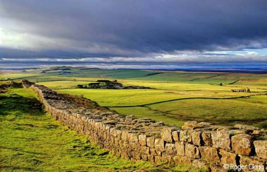
Hadrian's Wall, also called the Roman Wall, Picts' Wall, or Vallum Hadriani in Latin, was a defensive fortification in the Roman province of Britannia, begun in AD 122 in the reign of the emperor Hadrian. It ran from the banks of the River Tyne near the North Sea to the Solway Firth on the Irish Sea, and was the northern limit of the Roman Empire, immediately north of which were the lands of the northern Ancient Britons, including the Picts.
It had a stone base and a stone wall. There were milecastles with two turrets in between. There was a fort about every five Roman miles. From north to south, the wall comprised a ditch, wall, military way and vallum, another ditch with adjoining mounds. It is thought the milecastles were staffed with static garrisons, whereas the forts had fighting garrisons of infantry and cavalry. In addition to the wall's defensive military role, its gates may have been customs posts.
A significant portion of the wall still stands and can be followed on foot along the adjoining Hadrian's Wall Path. The largest Roman archaeological feature in Britain, it runs a total of 73 miles (117.5 kilometres) in northern England.[4] Regarded as a British cultural icon, Hadrian's Wall is one of Britain's major ancient tourist attractions.[5] It was designated as a UNESCO World Heritage Site in 1987.[6] In comparison, the Antonine Wall, thought by some to be based on Hadrian's wall (the Gillam hypothesis),[7] was not declared a World Heritage site until 2008.
It is a common misconception that Hadrian's Wall marks the boundary between England and Scotland. In fact Hadrian's Wall lies entirely within England and has never formed the Anglo-Scottish border. While it is less than 0.6 mi (1.0 km) south of the border with Scotland in the west at Bowness-on-Solway, in the east at Wallsend it is as much as 68 miles (109 km) away.
Leaderboard
- Dclo1:52
- perleblanche2:11
- FanASL2:12
- babray2:20
- evielou2:22
- aka0382:24
- glenestele2:27
- dogs_n_me2:31
- jigimaster2:32
- sihecht2:34
Comments
Please sign in to comment. Don't have a profile? Join now! Joining is absolutely free and no personal information is required.